
Speshari
Document register
- Poster1 pagePublished
- Presentation videoYouTubePublished
- Bill of materials1 pagePublished
- Team description paperNot shared
- Engineering journalNot shared
- Source codeNot shared
Sharing each document is the team's decision. “Not shared” means this team chose not to publish it, or did not submit one — not that it is missing from the archive.
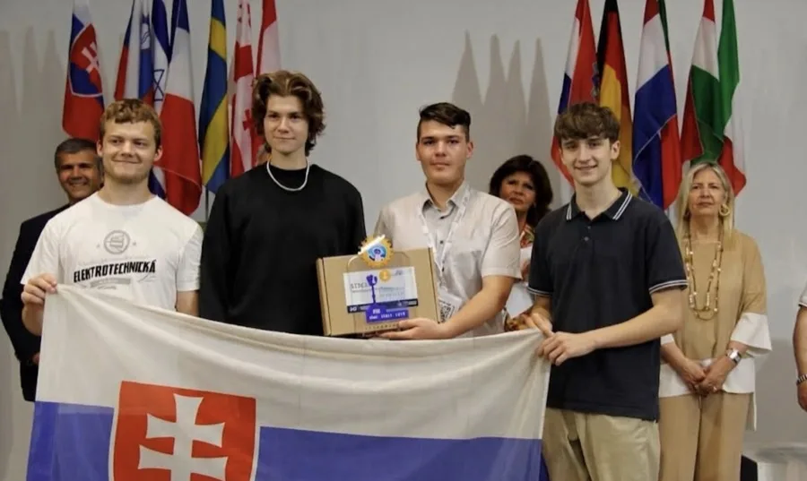
In their words
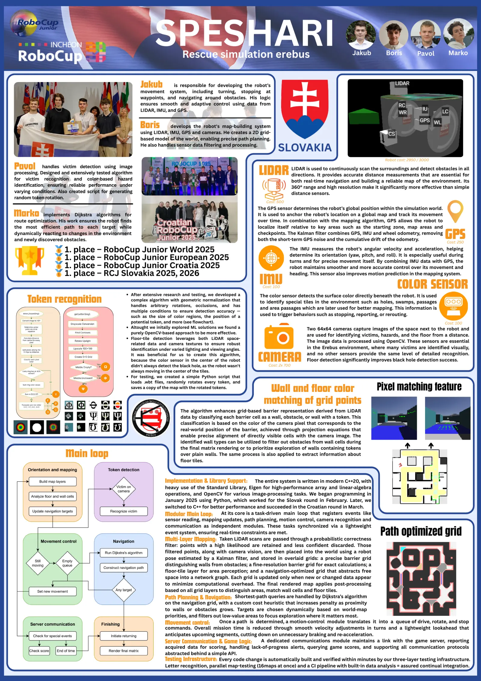
Speshari presents a fully autonomous robot designed to excel in the RoboCupJunior Rescue Simulation's Erebus subleague. Our solution combines precise mapping, intelligent navigation, and accurate victim recognition. The robot constructs a multi-layered 2D grid-based model of the environment using LiDAR, IMU, GPS, and dual side-mounted cameras, enabling robust localization and situational awareness. Navigation is guided by an advanced Dijkstra-based algorithm optimized for dynamic terrain and directional cost penalties, allowing for smooth and efficient motion through complex environments. Victim detection leverages custom image processing with OpenCV, achieving a high success rate under varied lighting and various angles. A modular C++ codebase supports independent development and testing of each subsystem—mapping, movement, token recognition, and server communication—maximizing flexibility and performance. Notably, our approach includes floor-type detection from both color sensors and camera input, enhancing trap and swamp avoidance. What sets Speshari apart is the integration of sophisticated mapping fidelity, direction-sensitive pathfinding and token recognition adapted on rotated tokens, all operating seamlessly in real-time within a lightweight and synchronized architecture. This synergy of precise hardware usage, robust algorithms, and team-driven development positions our robot as a contender in the simulation challenge.
Poster
Read the text of this document — 1151 words
SPESHARI Rescue simulation erebus Jakub Boris Pavol Marko
Jakub is responsible for developing the robot’s
movement system, including turning, stopping at
waypoints, and navigating around obstacles. His logic
ensures smooth and adaptive control using data from
LIDAR, IMU, and GPS.
Boris develops the robot's map-building system
using LIDAR, IMU, GPS and cameras. He creates a 2D grid-
based model of the world, enabling precise path planning.
He also handles sensor data filtering and processing.
Robot cost: 2950 / 3000
Pavol handles victim detection using image
processing. Designed and extensively tested algorithm
for victim recognition and color-based hazard
LIDAR LIDAR is used to continuously scan the surroundings and detect obstacles in all
directions. It provides accurate distance measurements that are essential for
both real-time navigation and building a reliable map of the environment. Its
identification, ensuring reliable performance under 360° range and high resolution make it significantly more effective than simple
varying conditions. Also created script for generating distance sensors.
random token rotation.
Cost: 500
The GPS sensor determines the robot’s global position within the simulation world.
Marko implements Dijkstra algorithms for It is used to anchor the robot’s location on a global map and track its movement
route optimization. His work ensures the robot finds over time. In combination with the mapping algorithm, GPS allows the robot to
the most efficient path to each target while localize itself relative to key areas such as the starting zone, map areas and
dynamically reacting to changes in the environment
and newly discovered obstacles.
checkpoints. The Kalman filter combines GPS, IMU and wheel odometry, removing
both the short-term GPS noise and the cumulative drift of the odometry. GPS
🥇🥇 1.1. place
Cost: 250
– RoboCup Junior World 2025 The IMU measures the robot’s angular velocity and acceleration, helping
place – RoboCup Junior European 2025 determine its orientation (yaw, pitch, and roll). It is especially useful during
🥇🥇 1.1. place – RoboCup Junior Croatia 2025
place – RCJ Slovakia 2025, 2026
turns and for precise movemnt itself. By combining IMU data with GPS, the
robot maintains smoother and more accurate control over its movement and
IMU
heading. This sensor also improves motion prediction in the mapping system.
Cost: 100 COLOR SENSOR
After extensive research and testing, we developed a
Token recognition complex algorithm with geometric normalization that
handles arbitrary rotations, occlusions, and has
The color sensor detects the surface color directly beneath the robot. It is used
to identify special tiles in the environment such as holes, swamps, passages
and area passages which are later used for better mapping. This information is
multiple conditions to ensure detection accuracy —
such as the size of color regions, the position of a used to trigger behaviors such as stopping, reporting, or rerouting.
potential token, and more (see flowchart). Cost: 100
Altought we initally explored ML solutions we found a Two 64x64 cameras capture images of the space next to the robot and
purely OpenCV-based approach to be more effective.
are used for identifying victims, hazards, and the floor from a distance.
Floor-tile detection leverages both LiDAR space-
The image data is processed using OpenCV. These sensors are essential
related data and camera textures to ensure robust
identification under varied lighting and viewing angles. in the Erebus environment, where many victims are identified visually,
It was beneficial for us to create this algorithm,
because the color sensor in the center of the robot
didn't always detect the black hole, as the robot wasn't
CAMERA
Cost: 2x 700
and no other sensors provide the same level of detailed recognition.
Floor detection significantly improves black hole detection success.
always moving in the center of the tiles.
For testing, we created a simple Python script that
loads .wbt files, randomly rotates every token, and
saves a copy of the map with the rotated tokens.
Wall and floor color Pixel matching feature
matching of grid points
The algorithm enhances grid-based barrier representation derived from LiDAR
data by classifying each barrier cell as a wall, obstacle, or wall with a token. This
classification is based on the color of the camera pixel that corresponds to the
real-world position of the barrier, achieved through projection equations that
enable precise alignment of directly visible cells with the camera image. The
identified wall types can be utilized to filter out obstacles from wall cells during
the final matrix rendering or to prioritize exploration of walls containing tokens
Main loop over plain walls. The same process is also applied to extract information about
floor tiles.
Implementation & Library Support: The entire system is written in modern C++20, with
heavy use of the Standard Library, Eigen for high‑performance array and linear‐algebra
operations, and OpenCV for various image‐processing tasks. We began programming in
January 2025 using Python, which worked for the Slovak round in February. Later, we
switched to C++ for better performance and succeeded in the Croatian round in March.
Modular Main Loop: At its core is a task‐driven main loop that registers events like
sensor reading, mapping updates, path planning, motion control, camera recognition and
communication as independent modules. These tasks synchronized via a lightweight
event system, ensuring real‐time constraints are met. Path optimized grid
Multi‑Layer Mapping: Taken LiDAR scans are passed through a probabilistic correctness
filter: points with a high likelihood are retained and less confident discarded. Those
filtered points, along with camera vision, are then placed into the world using a robot
pose estimated by a Kalman filter, and stored in overlaid grids: a precise barrier grid
distinguishing walls from obstacles; a fine‑resolution barrier grid for exact calculations; a
floor‐tile layer for area perception; and a navigation‑optimized grid that abstracts free
space into a network graph. Each grid is updated only when new or changed data appear
to minimize computational overhead. The final rendered map applies post‑processing
based on all grid layers to distinguish areas, match wall cells and floor tiles.
Path Planning & Navigation: Shortest‐path queries are handled by Dijkstra’s algorithm
on the navigation grid, with a custom cost heuristic that increases penalty as proximity
to walls or obstacles grows. Targets are chosen dynamically based on world‐map
priorities, and filters out low‑value areas to focus exploration where it matters most.
Movement control: Once a path is determined, a motion‐control module translates it into a queue of drive, rotate, and stop
commands. Overall mission time is reduced through smooth velocity adjustments in turns and a lightweight lookahead that
anticipates upcoming segments, cutting down on unnecessary braking and re‑acceleration.
Server Communication & Game Logic: A dedicated communications module maintains a link with the game server, reporting
acquired data for scoring, handling lack‑of‑progress alerts, querying game scores, and supporting all communication protocols
abstracted behind a simple API.
Testing Infrastructure: Every code change is automatically built and verified within minutes by our three-layer testing infrastructure.
Letter recognition, parallel map-testing (16maps at once) and a CI pipeline with built-in data analysis = assured continual integration.
1 page, rendered as images so they load quickly. The text above is the document's own, extracted from the PDF.
Presentation video
Hosted on YouTube. The player loads only when you press play.
Bill of materials
Read the text of this document — 111 words
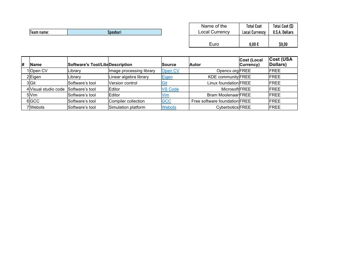
Name of the             Total Cost      Total Cost ($)
     Team name:                               Speshari                                 Local Currency         Local Currency    U.S.A. Dollars

                                                                                             Euro                 0,00 €            $0,00

                                                                                                              Cost (Local      Cost (USA
#     Name                 Software's Tool/LibrDescription                Source    Autor                     Currency)        Dollars)
    1 Open CV              Library             Image processing library   Open CV                Opencv.org FREE               FREE
    2 Eigen                Library             Linear algebra library     Eigen              KDE community FREE                FREE
    3 Git                  Software’s tool     Version control            Git               Linux foundation FREE              FREE
    4 Visual studio code   Software’s tool     Editor                     VS Code                   Microsoft FREE             FREE
    5 Vim                  Software’s tool     Editor                     Vim               Bram Moolenaar FREE                FREE
    6 GCC                  Software’s tool     Compiler collection        GCC       Free software foundation FREE              FREE
    7 Webots               Software’s tool     Simulation platform        Webots                Cyberbotics FREE               FREE
1 page, rendered as images so they load quickly. The text above is the document's own, extracted from the PDF.