
OGEE
Document register
- Poster1 pagePublished
- Presentation videoYouTubePublished
- Bill of materials2 pagesPublished
- Team description paperNot shared
- Engineering journalNot shared
- Source code10 KB · GitHubPublished
Sharing each document is the team's decision. “Not shared” means this team chose not to publish it, or did not submit one — not that it is missing from the archive.
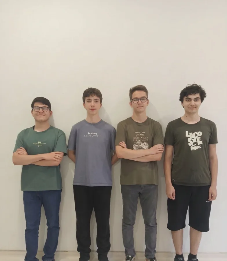
In their words
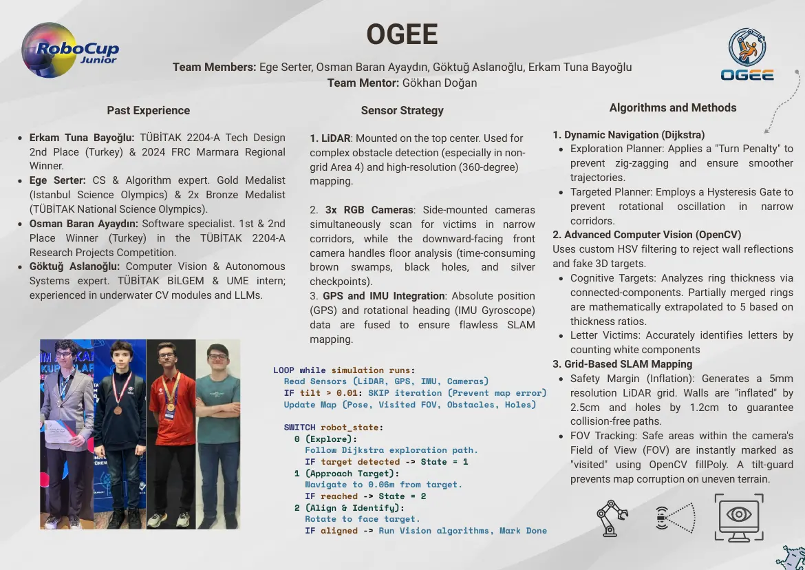
This paper presents the autonomous virtual rescue robot developed by Team OGEE for the RoboCupJunior Rescue Simulation 2026 competition.The system is designed to navigate a highly hazardous, simulated rescue environment completely autonomously, identifying victims and generating real-time environmental maps. Our robot platform integrates a differential-drive chassis with a specialized sensor array featuring high-resolution LiDAR, multi-angle RGB cameras, a Global Positioning System (GPS), and an Inertial Measurement Unit (IMU), staying strictly within the 3000-unit competition budget constraint. What sets our system apart from competitors is its highly integrated, modular sensor-fusion architecture. Locomotion is governed by an innovative dual-Dijkstra pathfinding system equipped with path-smoothing turn penalties and a strict hysteresis gate to eliminate frontier oscillations in tight corridors. For victim identification, the robot utilizes a custom OpenCV computer vision pipeline featuring a geometric Kasa least-squares circle-fit filter to discard fake 3D distractors and a robust connected-components apportionment engine to decode complex, multi-layered cognitive targets under severe camera skew. Simultaneously, a grid-based SLAM module fuses spatial sensor inputs into a 5 mm resolution matrix to secure the mapping bonus multiplier. The resulting architecture balances computational efficiency with exceptional resilience to sensor noise.
Poster
Read the text of this document — 367 words
OGEE
                            Team Members: Ege Serter, Osman Baran Ayaydın, Göktuğ Aslanoğlu, Erkam Tuna Bayoğlu
                                                        Team Mentor: Gökhan Doğan

               Past Experience                                    Sensor Strategy                                  Algorithms and Methods

Erkam Tuna Bayoğlu: TÜBİTAK 2204-A Tech Design          1. LiDAR: Mounted on the top center. Used for1. Dynamic Navigation (Dijkstra)
2nd Place (Turkey) & 2024 FRC Marmara Regional          complex obstacle detection (especially in non-   Exploration Planner: Applies a "Turn Penalty" to
Winner.                                                 grid Area 4) and high-resolution (360-degree)    prevent zig-zagging and ensure smoother
Ege Serter: CS & Algorithm expert. Gold Medalist        mapping.                                         trajectories.
(Istanbul Science Olympics) & 2x Bronze Medalist                                                         Targeted Planner: Employs a Hysteresis Gate to
(TÜBİTAK National Science Olympics).                   2. 3x RGB Cameras: Side-mounted cameras           prevent rotational oscillation in narrow
Osman Baran Ayaydın: Software specialist. 1st & 2nd    simultaneously scan for victims in narrow         corridors.
Place Winner (Turkey) in the TÜBİTAK 2204-A            corridors, while the downward-facing front    2. Advanced Computer Vision (OpenCV)
Research Projects Competition.                         camera handles floor analysis (time-consuming Uses custom HSV filtering to reject wall reflections
Göktuğ Aslanoğlu: Computer Vision & Autonomous         brown swamps, black holes, and silver         and fake 3D targets.
Systems expert. TÜBİTAK BİLGEM & UME intern;           checkpoints).                                     Cognitive Targets: Analyzes ring thickness via
experienced in underwater CV modules and LLMs.         3. GPS and IMU Integration: Absolute position     connected-components. Partially merged rings
                                                       (GPS) and rotational heading (IMU Gyroscope)      are mathematically extrapolated to 5 based on
                                                       data are fused to ensure flawless SLAM            thickness ratios.
                                                       mapping.                                          Letter Victims: Accurately identifies letters by
                                                                                                         counting white components
                                                LOOP while simulation runs:
                                                                                                     3. Grid-Based SLAM Mapping
                                                  Read Sensors (LiDAR, GPS, IMU, Cameras)                Safety Margin (Inflation): Generates a 5mm
                                                  IF tilt > 0.01: SKIP iteration (Prevent map error)     resolution LiDAR grid. Walls are "inflated" by
                                                  Update Map (Pose, Visited FOV, Obstacles, Holes)       2.5cm and holes by 1.2cm to guarantee
                                                  SWITCH robot_state:
                                                                                                         collision-free paths.
                                                    0 (Explore):                                         FOV Tracking: Safe areas within the camera's
                                                      Follow Dijkstra exploration path.                  Field of View (FOV) are instantly marked as
                                                      IF target detected -> State = 1                    "visited" using OpenCV fillPoly. A tilt-guard
                                                    1 (Approach Target):
                                                      Navigate to 0.06m from target.
                                                                                                         prevents map corruption on uneven terrain.
                                                        IF reached -> State = 2
                                                      2 (Align & Identify):
                                                        Rotate to face target.
                                                        IF aligned -> Run Vision algorithms, Mark Done
1 page, rendered as images so they load quickly. The text above is the document's own, extracted from the PDF.
Presentation video
Hosted on YouTube. The player loads only when you press play.
Bill of materials
Read the text of this document — 107 words
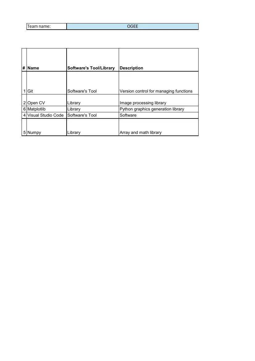
Team name:                                      OGEE

# Name               Software's Tool/Library   Description

1 Git                Software's Tool           Version control for managing functions

2 Open CV            Library                   Image processing library
6 Matplotlib         Library                   Python graphics generation library
4 Visual Studio Code Software's Tool           Software

5 Numpy              Library                   Array and math library
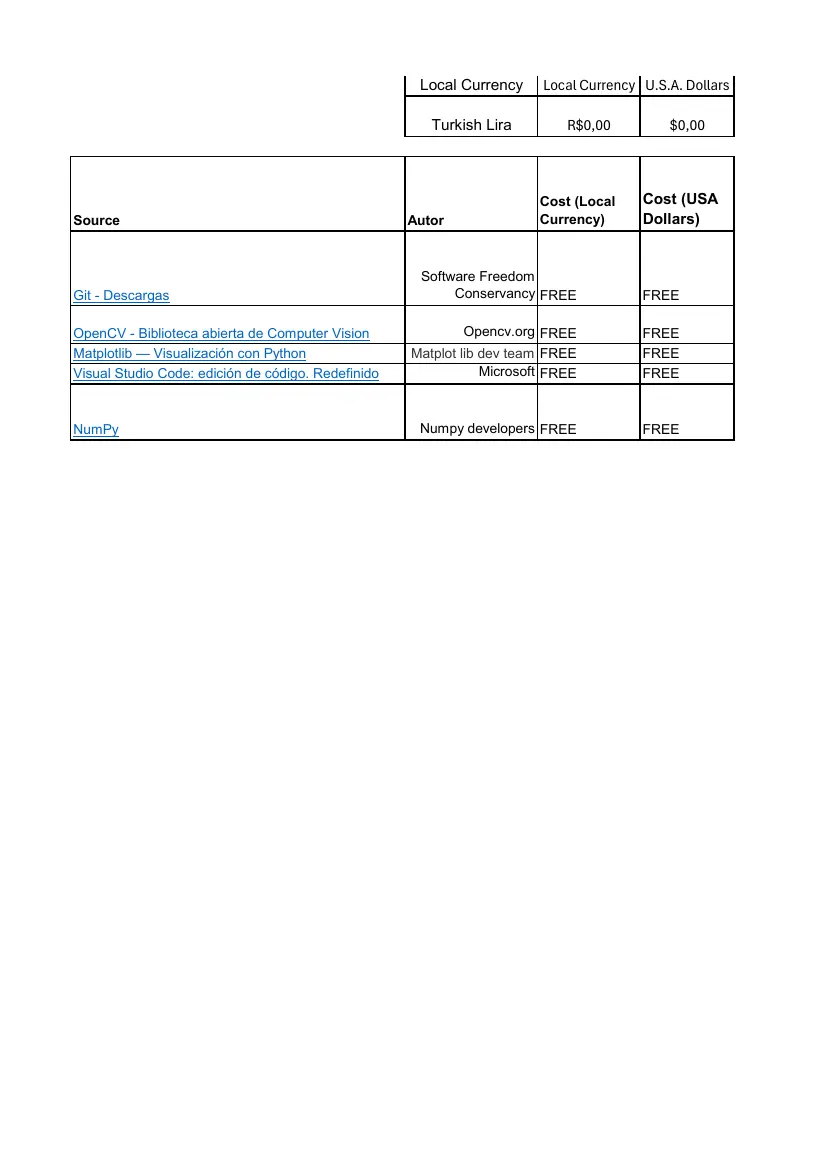
                                                     Local Currency     Local Currency U.S.A. Dollars

                                                       Turkish Lira         R$0,00         $0,00

                                                                        Cost (Local    Cost (USA
Source                                              Autor               Currency)      Dollars)

                                                     Software Freedom
Git - Descargas                                           Conservancy FREE             FREE

OpenCV - Biblioteca abierta de Computer Vision              Opencv.org FREE            FREE
Matplotlib — Visualización con Python               Matplot lib dev team FREE          FREE
Visual Studio Code: edición de código. Redefinido               Microsoft FREE         FREE

NumPy                                                Numpy developers FREE             FREE
2 pages, rendered as images so they load quickly. The text above is the document's own, extracted from the PDF.
Source code
The team's own source code, 10 KB. It is a download rather than part of this page, because a zip is something you open on your computer. It comes from GitHub, which some school networks block.