
Águabots

Simulation league · Brazil · RoboCup 2026

Document register

  1. Poster1 pagePublished
  2. Presentation videoYouTubePublished
  3. Bill of materials39 KBPublished
  4. Team description paperNot shared
  5. Engineering journalNot shared
  6. Source code17.1 MB · GitHubPublished

Sharing each document is the team's decision. “Not shared” means this team chose not to publish it, or did not submit one — not that it is missing from the archive.
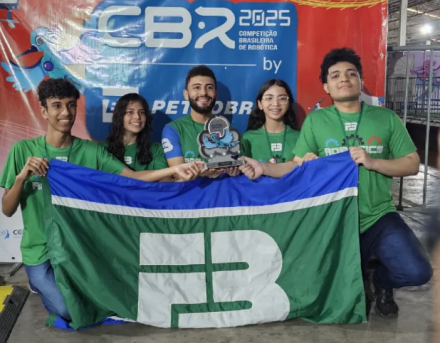
The Águabots team

In their words

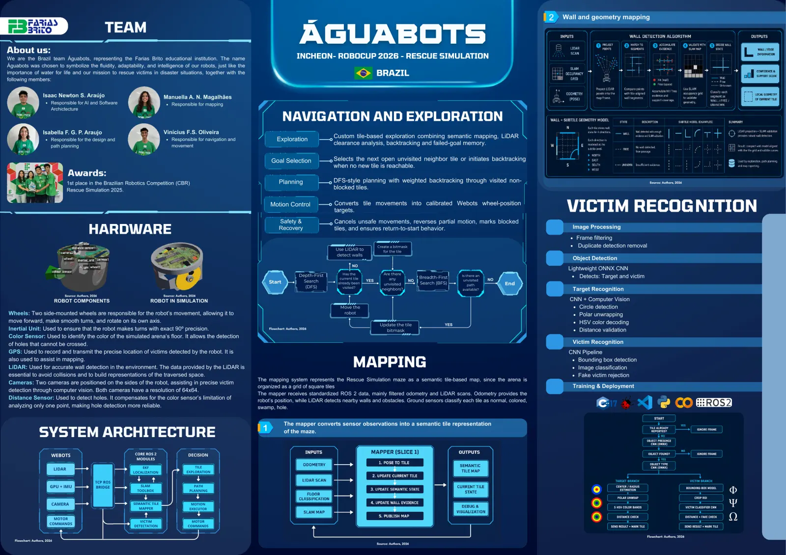
Our robot for RoboCupJunior Rescue Simulation 2026 is an autonomous rescue robot designed to explore a simulated maze, detect victims and wall tokens, avoid hazardous areas, build a semantic map, and return to the starting point within the competition time limit. The system combines a deterministic controller-side navigation strategy with ROS 2-based mapping and perception modules.

The movement system runs inside the Webots controller using the exploration_legacy library. It represents the arena as a discrete tile grid, reads LiDAR and ground-sensor information, selects safe neighboring tiles, executes calibrated wheel-position movements, and uses backtracking to return to the start. This approach was chosen because the Rescue Simulation maze is strongly tile-based and requires repeatable short movements rather than continuous generic path execution.

ROS 2 is used as a functional part of the final system for semantic mapping, victim and wall-token processing, visualization, debugging, and reporting support. The mapping module builds a tile-based semantic representation of the arena, while the vision pipeline uses ONNX neural networks and classical computer vision to detect victims and decode wall-token information.

The main strength of our system is the combination of competition-specific tile navigation, semantic mapping, and lightweight real-time perception in an integrated architecture.

Poster
Read the text of this document — 579 words
Wall and geometry mapping

                                                          TEAM
About us:
                                                                                                                                                ÁGUABOTS
We are the Brazil team Águabots, representing the Farias Brito educational institution. The name                                              INCHEON- ROBOCUP 2026 - RESCUE SIMULATION
Águabots was chosen to symbolize the fluidity, adaptability, and intelligence of our robots, just like the
importance of water for life and our mission to rescue victims in disaster situations, together with the                                                                             BRAZIL
following members:

                     Isaac Newton S. Araújo                                       Manuella A. N. Magalhães
                          Responsible for AI and Software                              Responsible for mapping
                          Archictecture

                                                                                                                                     NAVIGATION AND EXPLORATION
                     Isabella F. G. P. Araujo                                     Vinícius F.S. Oliveira
                                                                                                                                                              Custom tile-based exploration combining semantic mapping, LiDAR
                          Responsible for the design and                               Responsible for navigation and            Exploration
                          path planning                                                movement                                                               clearance analysis, backtracking and failed-goal memory.

                                                                                                                              Goal Selection                  Selects the next open unvisited neighbor tile or initiates backtracking
                                                                                                                                                              when no new tile is reachable.
                                      Awards:
                                      1st place in the Brazilian Robotics Competition (CBR)                                        Planning                   DFS-style planning with weighted backtracking through visited non-                                                           Source: Authors, 2026

                                      Rescue Simulation 2025.                                                                                                 blocked tiles.

                                                                                                                             Motion Control                   Converts tile movements into calibrated Webots wheel-position
                                                                                                                                                              targets.                                                                                   VICTIM RECOGNITION
                                                                                                                                   Safety &                   Cancels unsafe movements, reverses partial motion, marks blocked
                                                 HARDWARE                                                                          Recovery                   tiles, and ensures return-to-start behavior.                                                 Image Processing
                                                                                                                                                                                                                                                            Frame filtering
                                                                                                                                                                                     Create a bitmask                                                       Duplicate detection removal
                                                                                                                                                              Use LIDAR to              for the tile
                                                                                                                                                              detect walls
                                                                                                                                                                                                                                                           Object Detection
                                                                                                                                                                       NO
                                                                                                                                                                                                                                                         Lightweight ONNX CNN
                                                                                                                                                Depth-First       Has the                Are there
                                                                                                                                                                current tile                any               Breadth-First    Is there an                   Detects: Target and victim
                                                                                                                                                  Search                       YES                       NO                     unvisited    NO
                                                                                                                            Start                              already been              unvisited            Search (BFS)                        End
                                                                                                                                                                                                                                   path
                                                                                                                                                   (DFS)          visited?              neighbors?                              available?                 Target Recognition
                                  Source: Authors, 2026                           Source: Authors, 2026
                              ROBOT COMPONENTS                            ROBOT IN SIMULATION                                                                                                                                                             CNN + Computer Vision
                                                                                                                                                                Move the                                                                                    Circle detection
Wheels: Two side-mounted wheels are responsible for the robot’s movement, allowing it to                                                                         robot                                                                                      Polar unwrapping
move forward, make smooth turns, and rotate on its own axis.                                                                                                                                                                                                HSV color decoding
                                                                                                                                                                                      Update the tile                    YES
Inertial Unit: Used to ensure that the robot makes turns with exact 90º precision.                                           Flowchart: Authors, 2026
                                                                                                                                                                                        bitmask                                                             Distance validation
Color Sensor: Used to identify the color of the simulated arena’s floor. It allows the detection
of holes that cannot be crossed.                                                                                                                                                                                                                           Victim Recognition
GPS: Used to record and transmit the precise location of victims detected by the robot. It is                                                                                                                                                            CNN Pipeline
also used to assist in mapping.
LiDAR: Used for accurate wall detection in the environment. The data provided by the LiDAR is                                                                          MAPPING                                                                             Bounding box detection
                                                                                                                                                                                                                                                           Image classification
essential to avoid collisions and to build representations of the traversed space.                                                                                                                                                                         Fake victim rejection
                                                                                                                        The mapping system represents the Rescue Simulation maze as a semantic tile-based map, since the arena is
Cameras: Two cameras are positioned on the sides of the robot, assisting in precise victim
                                                                                                                        organized as a grid of square tiles                                                                                                Training & Deployment
detection through computer vision. Both cameras have a resolution of 64x64.
                                                                                                                        The mapper receives standardized ROS 2 data, mainly filtered odometry and LiDAR scans. Odometry provides the
Distance Sensor: Used to detect holes. It compensates for the color sensor’s limitation of                              robot’s position, while LiDAR detects nearby walls and obstacles. Ground sensors classify each tile as normal, colored,
analyzing only one point, making hole detection more reliable.                                                          swamp, hole.

                                                                                                                                      The mapper converts sensor observations into a semantic tile representation

                  SYSTEM ARCHITECTURE                                                                                                 of the maze.

                          WEBOTS                                   CORE ROS 2                     DECISION
                                                                    MODULES

                                                                      EKF                            TILE
                              LIDAR
                                                                  LOCALIZATION                   EXPLORATION

                                                     TCP ROS
                         GPU + IMU                   BRIDGE           SLAM                          PATH
                                                                    TOOLBOX                       PLANNING

                         CÂMERA
                          CAMERA                                  SEMANTIC TILE                    MOTION
                                                                     MAPPER                       EXECUTOR

                           MOTOR
                         CÂMERA                                       VICTIM                       MOTOR
                         COMMANDS
                                                                   DETECTATION                   COMMANDS

                                                                                                                                                                                                                                                                                          Flowchart: Authors, 2026
   Flowchart: Authors, 2026
                                                                                                                                                                                     Source: Authors, 2026

Open as plain text

1 page, rendered as images so they load quickly. The text above is the document's own, extracted from the PDF.

Download the original PDF (5.9 MB) from GitHub

Presentation video

Hosted on YouTube. The player loads only when you press play.

Open in YouTube

Bill of materials

Shown as the original PDF, because this one is smaller that way and its text stays selectable and searchable.

Open Bill of materials

Source code

The team's own source code, 17.1 MB. It is a download rather than part of this page, because a zip is something you open on your computer. It comes from GitHub, which some school networks block.

Download Águabots's source code